
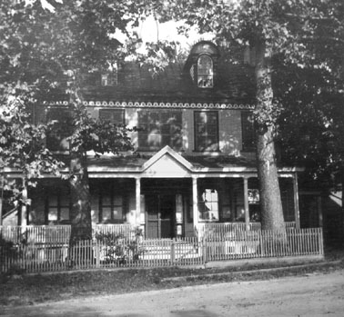
This is a photo of the Cookstown Tavern, circa 1906, as photographed
by my grandparents, Samuel Rogers, and
Emily Bird Wright. They were
visiting the Jacobstown and Cookstown, Burlington County, New Jersey area
(Cookstown/Crosswicks Map [377KB, 150 dpi])
** with other family members, among them my great grandmother,
Laura A. (Lamb) Wright.
My great grandmother lived in this residence as a little girl,
when her parents, Nehemiah Lamb and
Mary Ann Worth owned this property.
Nehemiah bought this property on
11 February 1856 (See Deed
transcription below) and sold the property on 24 March 1864 to Aaron
Eldridge of Millstone Township, Monmouth County, New Jersey. (NJ State
Archives Deeds, Burlington County Deeds, Reel #3641, Vol. A7, pp. 428-430)
Nehemiah bought this property for $2,500 and sold it for
$3,000. When he sold the property, it was referred to as "all that
certain tavern property." As one can see by the dates of ownership, the
Inn/Tavern was occupied by my great great grandparents during the Civil War,
and my great grandmother, Laura A. (Lamb) Wright
shared stories with her grandchildren about Civil War soldiers coming to the
Tavern during this time, at which time she would be sent upstairs, being
somewhat fearful of these uniformed men on horseback. Because Nehemiah
was of Quaker background, one can only assume that he was no longer a practicing
Quaker at this point, since he owned a tavern. (Nehemiah's first wife,
Ann Patterson is buried in the Springfield Quaker Burying Grounds.)
**This is an 1876 map taken from the photostat negative collection of my late aunt, Laura E. Rogers, and is viewable online at almost 200%. You may save it, thus being able to view it with Adobe Photoshop or some other image editor. You will note the "Wid. Mary A. Lamb" on this map. This is
Mary Ann (Worth) Lamb, widow of the Nehemiah Lamb who bought this Cookstown Tavern in 1856. Nehemiah died in 1872, four years before the date of this map, and by 1880, Mary Ann had remarried Theodore Huster.
In the 1883 publication, History of Burlington and Mercer Counties by Woodward and Hageman, there is some brief history of the Cookstown area. This history mentions that "George C. Davis built a substantial Federal-style tavern/hotel in 1825, The Cookstown House. In 1883, the town consisted of two stores, two hotels, a church, a blacksmith shop, a post office, a hay press, grist mill, a fertilizer and agricultural implement depot, and houses sheltering a population of about 150."
In 1975, the Burlington County Inventory and Survey of Historic,
Architectural and Cultural Resources apparently used 1938 photos of this
building (then Cox's Tavern), from the files of
HABS's
(Historic American Buildings Survey) to determine in part, if this building
qualified for the National Register of Historic Buildings.
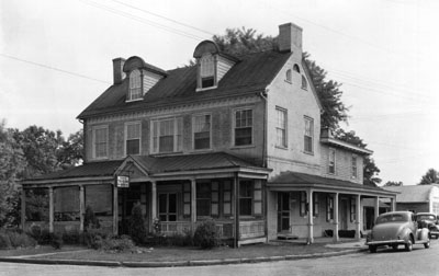
It was considered a possibility, but apparently nothing ever came of it, unfortunately, as the building was a grocery and deli in 1991. (About the only original part of the building left at that point was the basement, which my family and I were graciously shown, by the then current owners.) According to the 1975 survey, the building's address was Main Street and Bunting Bridge Road, Cookstown, New Jersey. The original building was a five-bay house, with two equal sized rooms on either side of the stairwell, the actual building measuring 20' x 40'. For those interested in architecture, the survey also mentioned that there were classical motifs, including roundels in door frame, columns framing dormers, and fireplace mantels. The original building was described as a "carefully detailed, well-proportioned piece of Federal architecture."
Following is the transcription of the deed showing when Nehemiah Lamb bought this Tavern/Inn property. You are certainly able to use this deed for your personal research, but kindly source it "from whence it came." The transcription was done by me, and the source is Donna Speer Ristenbatt's web site, On the Trail of Our Ancestors. For the original source notation, you may write to me by e-mail.
This Indenture made this Eleventh day of February in the year of our Lord one thousand eight hundred and fifty six Between Joseph Cliver and Sarah his wife of the village of Wrightstown in the township of New Hanover and George Sykes of the township of Springfield in the County of Burlington and state of New Jersey parties of the first part and Nehemiah Lamb of the village of Cookstown in the township of New Hanover in the County of Burlington and state aforesaid.
Whereas Charles Ivins claimed title to a certain farm or plantation and mill property of which the hereinafter described premises are a part by virtue of a deed of conveyance duly executed under the hands and seals of Benjamin Rogers and wife bearing date the third day of March Anno Domini one thousand eight hundred and twenty five and recorded in Book U.2. of Deeds page 292 in the Clerk's office at Mount Holly and the said Charles Ivins and Elizabeth his wife by deed dated the thirtieth day of March in the year last aforesaid and recorded in Book S2 of Deeds page 508 in the Clerk's office at Mount Holly aforesaid granted ninety seven hundredths of an acre, part and parcel of to George C. Davis in fee who with Ann his wife granted and conveyed the said ninety seven hundredths of an acre of land to Benjamin W. Rogers in fee by deed dated the twenty third day of March eighteen hundred and thirty three and Recorded in Book E?3 of Deeds page 483 in the Clerk's office aforesaid And the said Benjamin W. Rogers by deed dated the fifteenth day of January eighteen hundred and thirty five and recorded in Book I3 of Deeds page 586 in the Clerk's office aforesaid granted and conveyed the said lot of land to George W. Ivins in fee and the aforesaid Charles Ivins and Elizabeth his wife by deed dated the third day of September Eighteen hundred and thirty three and recorded in Book H3 of Deeds page 297 in the Clerk's Office at Mount Holly aforesaid granted and conveyed the remainder of the said farm or plantation and Mill property to Joseph Hartshorne in trust for the use of John B. Keeler and the said Joseph Hartshorne trustee as aforesaid by deed dated the first day of June Anno Domini eighteen hundred and thirty five and recorded in Book N3 of Deeds page 110 in the Clerk's office aforesaid granted and conveyed one other lot or parcel of land to the said George W. Ivins in fee and the said George W. Ivins being seized of the two above described lots or parcels of land adjoining each other with Eliza his wife granted and conveyed the said lots or parcels of land to his nephew Thomas W. Ivins in fee by Deed dated the third day of April Anno Domini Eighteen hundred and forty one and recorded in Book A4 of Deeds page 131 in the Clerk's office at Mount Holly aforesaid.
And whereas William M. Knight of the Borough of Bordentown claimed title to the two above described lots or parcels of land by virtue of a deed of conveyance from Edward Fields and wife bearing date the tenth day of July Anno Domini Eighteen hundred and forty five and Recorded in Book S4 of Deeds page 72 in the Clerk's office at Mount Holly, and the said William M. Knight and Martha his wife by deed bearing date the twenty fifth day of March Eighteen hundred and forty seven granted the said lots of land to Isaac Cliver which deed is Recorded in Book B5 of Deeds page 327, in the Clerk's office aforesaid And Whereas Abraham Gaskill Sheriff of the County of Burlington by virtue of an execution to him directed levied and seized upon the aforesaid two lots or parcels of land and conveyed the same as the property of the said Isaac Cliver to George B. Pancoast by deed dated the thirtienth[sic] day of December eighteen hundred and fifty and recorded in Book B5 of Deeds page 329 in the Clerk's Office aforesaid at Mount Holly, and the said George B. Pancoast and Deborah his wife by deed dated the twenty first day of December in the year last aforesaid and Recorded in Book B5 of Deeds page 340 in the Clerk's office at Mount Holly aforesaid granted the two above described lots or parcels of land to the said Joseph Cliver and George Sykes the grantors herein first named in fee and the said Joseph Cliver and George Sykes claim title to one one [sic] of the lot or parcel of land containing two hundredths of an acre by virtue of a deed of conveyance from Ezekiel Sexton dated the sixteenth day of July Anno Domini Eighteen hundred and fifty three and intended to be forthwith recorded in the same book with this indenture in the Clerk's office at Mount Holly which last mentioned lot includes a small strip or gore of land adjoining the two above described lots or parcels of land as by reference to the above recorded deeds or the record thereof the Chain of Antecedent title will more fully appear.
Now this Indenture Witnesseth that the said Joseph Cliver and Sarah his wife and George Sykes parties of the first part for and in consideration of the sum of two thousand five hundred dollars lawful money of the United States to them in hand or ??? by the said Nehemiah Lamb at the ensealing and delivery hereof the ?? payment whereof is hereby owned and acknowledged ??? sold conveyed and confirmed and by these ??? (The lower right hand corner of this deed page has darkened and is difficult to read.) fully clearly and absolutely grant bargain sell and convey and confirm unto the said Nehemiah Lamb and to his heirs and assigns forever all the following described lot or parcel of land including the ? first and third lots herein before described and the principal part of the second lot situate in and near the village of Cookstown in the township of New Hanover in the County of Burlington and state of New Jersey and butted and bounded as follows.
Beginning at a stone at the Easterly edge of the main road or street running southerly through the village of Cookstown and at the Southerly edge of the road leading to Horners Bridge over Crosswicks Creek which stone is also the beginning and Northwest corner of William Pancoast's lot and is also the Beginning Corner to John B. Keeler's Mill property and farm or plantation which stone is distant twenty six links on a course North sixty four degrees and fifteen minutes West from the Northwest corner of the cellar wall under William Pancoast's dwelling house and also distant eighty four links on a course South thirty eight degrees and fifteen minutes West from the South west corner of the cellar ? under the Brick Farm house on the premises hereby conveyed and from said stone or Beginning running along the main road or street according to the magnetic position of the needle as the several courses around the premises were run by Joseph K. Hulme and George? Sykes in June Eighteen hundred and fifty two.
1st. North one degree west two chains and Eighty one links to the South East corner the bridge where the said main road or street crosses the mill stream or creek a little Easterly from the Mill then 2nd) down the south? edge of the mill creek or brook which was formerly called North run or Tomlinsen's run the several courses thereof (as per deed by Charles Ivins and wife to George C. Davis aforesaid) the general course being North eighty one degrees and thirty minutes East four chains and two links to a stake or stone on the south side of said run or creek the Beginning Corner to lot conveyed by Joseph Hartshorne to George W. Ivins then along the southern edge of the creek. 3rd. North eighty nine degrees East three chains and forty links then still along the Southerly edge of the creek. 4th. South eighty two degrees and thirty minutes East four? chains and seventy five links then still along the southerly edge of the creek. 5th. North fifty one degrees East one chain and sixty seven links to the line of Thomas N. Emley and Henry Emley's land then leaving the creek and running along said Emley's line. 6th. ?-four degrees and fifteen minutes East two chains and two chains and twenty-? links to a stone on the slope of the bank then by land conveyed by Joseph Cliver and George Sykes to Thomas N. Emley and Henry Emley. 7th. South eleven degrees West four chains and forty links to a stone in the aforesaid road from near the bridge at Cookstown to Horner's Bridge on Crosswicks Creek and which stone is corner to said Emley's land then along said road. 8th. North seventy nine degrees west? eleven chains and thirty nine links to a stone in said road corner to Ezekiel Sexton's land it being also the beginning ? to the strip or gore of land the said Joseph Cliver and George Sykes purchased of Ezekiel Sexton their part by said Sexton's land and part by William Pancoast's land. 9th. South eighty seven degrees and forty five minutes West two chains and ninety two links to the beginning containing five acres and eighty six hundredths of an acre of land strict measure.
Together with all things thereunto appertaining or in anywise belonging as Vol. W-5 part or parcel of the same or reputed so to be and the reversions and remainders rents issues and profits thereof and all the estate, right, title, interest, property, possession, use, claim and demand whatsoever either in law or equity of them the said Joseph Cliver and Sarah his wife and George Sykesor either of them of in and to the same. To Have and to Hold the above described lot or parcel of land with the buildings and improvements, and appurtenances to the said Nehemiah Lamb his heirs and assigns to the only proper use, benefit, and behoof of the said Nehemiah Lamb his heirs and assigns forever.
And the said Joseph Cliver and George Sykes for themselves their heirs, executors and administrators do by these presents covenant and agree to and with the said Nehemiah Lamb his heirs and assigns that they the said Joseph Cliver and George Sykes and their heirs all and singular the land and premises herein above described and granted or ? mentioned or intended so to be with the appurtenances unto the said Nehemiah Lamb his heirs and assigns against them the said Joseph Cliver and George Sykes and their heirs and against all and every other persons whomsoever lawfully claiming or to claim the same or any part thereof by from or under them the said Joseph Cliver and George Sykes shall and will by these presents warrant and forever defend. In witness whereof the said Joseph Cliver and Sarah his wife and George Sykes have herunto set their hands and affixed their seals this eleventh day of February Anno Domini one thousand eight hundred and fifty six. Signed sealed and delivered in the presence of us, Daniel Lame.
Signed Joseph Cliver, LS, Sarah Cliver, LS, Geo.Sykes, LS
This deed was taken and acknowledged before Daniel Lame, one of the Masters of the High Court of Chancery and recorded 5 March 1856.
|
|
|
|
|
|
![Cookstown/Crosswicks Map [377KB, 150 dpi]](images/cooksmap.jpg)